 EMODnet Product Catalogue
Contact for the resource
Spanish Institute of Oceanography
Type of resources
Available actions
Topics
Keywords
Contact for the resource
Provided by
Formats
Representation types
Update frequencies
status
Scale 1:
From
1
-
2
/
2
-
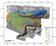
Cartography associated with the Management of the AMP and ZEC in Le Danois Bank. Results of research works with multibeam bathymetry, ROV┬┤s, submarine photography, bottom reflectivity, seismic profiles and the granulometric and biological analyses of the samples gathered during the surveys.
-
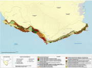
Cartography of benthic communities to promoting adequate strategies for the use, management and conservation of littoral areas depending on the ecological value of the different benthic communities established and on the local geographical distribution.